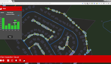
With the addition of the PipeLogix GIS module added to ArcMap, supervisors can view all surveys performed on an asset. The toolbar filters survey data in the master database to highlight pipes with selected conditions, grades, or score values, allowing the user to link to the movie or survey. Survey conditions can be exported to a shape file or a geodatabase feature class. When opened in ArcMap, this layer displays the condition along the length of pipe. Selecting the condition will link to the movie and jump to the correct footage for viewing. Seeing the problem and where it exists on the pipe can make it easier to schedule repair and cleaning crews. The system is compatible with ArcGIS 10.0 through 10.5. 866-299-3150; www.pipelogix.com.
GIS GPS - PipeLogix GIS
Related Stories
Discussion
Comments on this site are submitted by users and are not endorsed by nor do they reflect the views or opinions of COLE Publishing, Inc. Comments are moderated before being posted.


