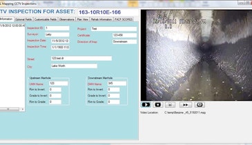
PipeLogix software from PipeLogix Inc. offers the power to cost-effectively collect data and accurately evaluate underground infrastructure assets. It is PACP certified, works with all CCTV systems and is backed by after-sales technical support. Data can be captured, analyzed and shared about mainlines, laterals, manholes, grout and inclinometer surveys. The program offers various reporting features. Built-in GIS tools enable the user to import accurate asset details from map programs directly into the pipe survey form; export shape files or feature classes in geodatabases from the program based on completed surveys, defect types, new assets found or pipe score values; and easily identify surveyed pipes on maps with color coding. A specially designed tool bar can be added to Esri ArcMap to quickly filter survey data. Movies, reports or survey detail can be viewed within ArcMap. The program also interfaces with many popular industry standard asset management programs. 866/299-3150; www.pipelogix.com.
Software - Pipe inspection software
The ability to quickly and efficiently locate a blockage or damage in a municipal water or sewer pipeline can save utilities and taxpayers substantial sums. This selection of inspection camera systems, leak detection equipment, data recorders and software programs can help municipalities and contractors stay ahead of potential problems.
Related Stories
Discussion
Comments on this site are submitted by users and are not endorsed by nor do they reflect the views or opinions of COLE Publishing, Inc. Comments are moderated before being posted.


